Oceanographic and Climatic Factors
What does the Rocky Intertidal Zone look like, you might ask ponderously. Take a look at the photo below to find out!


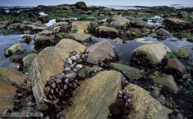 |
| Photo taken by Martin Gabriel. |
What exactly is the Rocky Intertidal Zone?
The rocky intertidal zone provides linkage between terrestrial systems and marine systems. They are high stress, high impact areas. "Conditions including wave action, changes in salinity, thermal stress, alternating periods of exposure and submersion, and exposure to winter ice have necessitated that organisms develop strategies to survive in this stressful environment". For example, some animals like mussels have hard shells to protect themselves, and some algae can hide under rocks to protect from predation. Rocky intertidal zones do many things for the environment and planet, such as stabilizing shorelines, "protecting upland areas against the eroding action of waves and the impacts of storm surges and sea level rise; creating dramatic vistas; offering easily accessible coast for recreation, education, and research; providing haul-out areas for seals; supporting the diets of foraging birds; and supporting diverse organisms vital to the base of the food web." (Massachusetts Bays Program)
There are many layers in the intertidal Zone, as can be seen in the two photos below from Bigelow Laboratories and a teacher.

Rocky intertidal areas show distinct zonation due to wave activity. While there are four different zones in the Rocky Intertidal Zone, zonation can also be affected by how heavy the waves are. If waves are particularly heavy in one area, that area will favor organisms that can hang on, such as barnacles. (Massachusetts Bays Program) The four zones are as follows:
Splash Zone
The splash zone is named because it gets hit with the spray from waves. It is covered in lichens and algae. Not much else thrives there, as it is so terrestrial it can be hard for marine organisms to thrive. It is rarely - if ever - submerged in water. Colonization is determined by who can survive. (Massachusetts Bays Program)
High Intertidal Zone
The high intertidal zone is submerged during high tide and exposed for the majority of the day. This zone provides little shelter from the typically terrestrial elements, such as cool air, wind, and hot sun. But the typically twice daily submersion in water brings the necessary sustenance (food, dissolved oxygen, nutrients, etc) for marine organisms to thrive. It frequently has a high barnacle population. (Massachusetts Bays Program)
Mid Intertidal Zone
The mid intertidal zone is similar to the high intertidal zone in the sense that it is submerged typically twice a day, but differs because it is submerged longer. Because of increased access to sustenance, this is a more habitable environment for marine organisms. The mid intertidal zone is typically dominated by gastropods, mussels and algae, which provide shelter for the mobile organisms that inhabit this zone. Much like in the high intertidal zone, predation, competition for space, settlement of young, and availability of food will affect which species and organisms dominate the environment. (Massachusetts Bays Program)
Low Intertidal Zone
The low intertidal zone is submerged almost all of the time, and therefore can support more diverse communities and habitats. (Massachusetts Bays Program)
 |
| A fine example of a tide pool. |
Additionally, rocky intertidal zones are also host to tide pools. These pools can differ from the surrounding environments in terms of life seen. They are pockets of rock sometimes subject to flooding. When it comes to life, there is no hard and fast rule about who lives in and occupies tide pools - the organisms change with the zone and with where in the world the pools are. (Massachusetts Bays Program)
Sources
- Gabriel, Martin. Rocky Intertidal Zone. Digital image. Nature Library. BBC, n.d. Web. 26 Apr. 2017. <http://ichef.bbci.co.uk/naturelibrary/images/ic/credit/640x395/i/in/intertidal_zone/intertidal_zone_1.jpg>.
- Hoopman. Rocky Intertidal Zone. Digital image. Riverview Middle School Science. PBWorks, n.d. Web. 26 Apr. 2017. <http://hoopmanscience.pbworks.com/f/1391091742/Intertidal%20Zone%20zones.jpg>
- "Rocky Intertidal." Massachusetts Bays Program. Commonwealth of Massachusetts, 31 Dec. 2011. Web. 27 Apr. 2017. <http://www.mass.gov/envir/massbays/bhha_rockyintertidal.htm>.
- Rocky Intertidal Zone. Digital image. Exploring Orange County. N.p., n.d. Web. 26 Apr. 2017. <http://ocexplore.org/wp-content/uploads/2016/02/corona-del-mar-tide-pools-1024x683.jpg>.
- Rocky Intertidal Zones. Digital image. Marine Intertidal Zone Investigation. Bigelow Laboratory for Ocean Sciences, n.d. Web. 26 Apr. 2017. <https://www.bigelow.org/archive/mitzi/images/zones/GZ_4_lg_label.jpg>.
- Allen, Larry Glenn., Daniel J. Pondella, and Michael H. Horn. Ecology of Marine Fishes: California and Adjacent Waters. Berkeley: U of California, 2006. Print.
- Helmuth, Brian ST, and Gretchen E. Hoffman. "Microhabitats, Thermal Heterogeneity, and Patterns of Physiological Stress in the Rocky Intertidal Zone." University of Chicago Press Journals 201.3 (2001): n. pag. Web. 27 Apr. 2017.


Comments
Post a Comment